

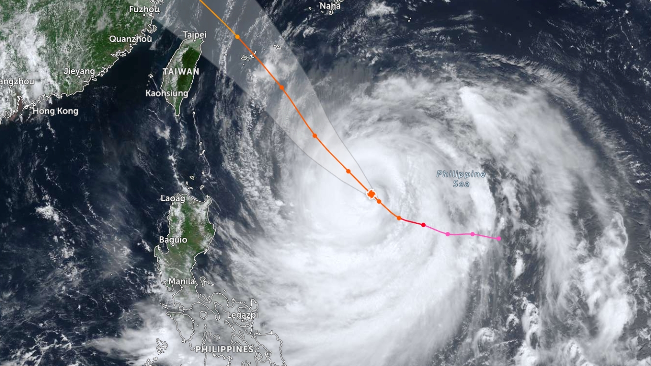
Taiwan and China are accelerating preparations for Typhoon "Bavi," which is moving closer and is expected to pass near northern Taiwan before making landfall in China's Fujian province on 11 Jul. Meteorologists warn this storm could be the largest Taiwan has faced in nearly 40 years and the strongest in the region since 2024.
Taiwan, China, and Japan are swiftly implementing measures to confront Typhoon "Bavi," currently moving southeast of Taiwan in the Pacific Ocean. Although its maximum wind speed has slightly decreased to about 205 kilometers per hour, it remains a dangerous storm likely to cause severe damage in the coming days.
China's National Meteorological Center predicts the storm will pass northern Taiwan before making landfall in Fujian province in eastern China on the evening of 11 Jul. The typhoon’s diameter is about 1,000 kilometers, roughly the width of France.
Taiwan's Central Weather Bureau states Bavi could become the largest typhoon to approach Taiwan since 1987 and is a rare large storm in recent years. A marine warning may be issued starting Thursday, followed by a land warning on Thursday evening or early Friday.
Taiwan’s President Lai Ching-te posted on Facebook urging citizens to prepare food, drinking water, flashlights, medications, and essential items. He shared a video demonstrating how to pack an "emergency bag" capable of supporting survival for at least three days in case of disaster.
A tropical cyclone expert from Imperial College London said Bavi accumulated energy over the Pacific Ocean for an extended period, absorbing vast amounts of heat and moisture, which gives it the potential to cause severe damage near the coast. Even small shifts in its path could significantly affect impacted areas.
AccuWeather assesses that if the storm maintains its predicted strength, Bavi will be the strongest typhoon in the Asia-Pacific region since Super Typhoon "Gongrey" in 2024. Though wind speeds are expected to weaken starting Thursday, it will remain dangerous to Taiwan and eastern China into early next week.
Taiwanese authorities have fully escalated precautionary measures by suspending passenger ferry services to several offshore islands, closing tourist attractions on Guishan Island ("Turtle Island") from Thursday to Sunday, and expediting the evacuation of tourists from Green Island and Lanyu Island, as well as transporting food and essential supplies into affected areas.
Additionally, farmers in many areas are hastening crop harvests ahead of the storm’s landfall. Fishermen are pulling boats from the water to prevent damage, while fresh markets and supermarkets in several cities report about a 30% increase in purchases of food and essential goods.
Taiwan’s highway authority is closely monitoring landslide-prone routes and may restrict or close traffic on the Antai Bridge if wind speeds reach dangerous levels. Taipei is expected to enter the storm’s outer influence Friday night, with gusts up to 149 kilometers per hour and cumulative rainfall reaching 400 millimeters, especially in mountainous areas prone to heavy rain and landslides.
Japan’s Meteorological Agency issued warnings for Okinawa Prefecture to watch for strong winds, storm surges, floods, and landslides on Friday and Saturday. Scientists warn that climate change and the formation of El Niño this year may cause more frequent and intense storms in East Asia.