The wildfire situation in Mae Hong Son province has worsened daily, making firefighting by manpower ineffective due to complex terrain conditions. The fire has now spread across all seven districts. The governor convened an urgent meeting to find solutions and requested helicopter support for firefighting missions. Meanwhile, forest units patrol day and night, using drones to detect illegal forest entry and arson, aiming to prevent the situation from worsening further.
On 31 Mar 2026 GMT+7, Mr. Wiboon Waewbandit, Governor of Mae Hong Son, revealed that the wildfire situation has intensified daily, causing firefighting by personnel to fail in meeting targets. The fires occur in steep mountainous terrain and rocky areas, making it impossible to climb and extinguish the fires on foot. In response, the province held meetings to seek helicopter support from the Ministry of Natural Resources and Environment and the Third Army Region to assist firefighting efforts. The fires have spread across all seven districts: Pai, Pang Mapha, Mueang Mae Hong Son, Khun Yuam, Mae La Noi, Mae Sariang, and Sop Moei.

On 30 Mar 2026 GMT+7, Mr. Likhit Waiprom, head of Salawin National Park, reported that a wildfire patrol officer slipped and fell while working to extinguish a fire. The officer received initial first aid and was taken to Mae Sariang Hospital, where X-rays showed a broken right arm. The hospital applied a cast, provided medication, and allowed the officer to return home with a follow-up X-ray scheduled for 16 Apr 2026 GMT+7. Patrols continue rigorously to prevent illegal natural resource destruction and forest arson, with warnings issued to locals prohibiting any unlawful activities.

Mr. Piyapong Thammapanya, acting head of Mae Sariang National Park, reported that during a wildfire patrol, a fire was found at coordinates 47Q 391814 E 2006517 N near Road 108 (Mae Sariang-Mae Ho). Firefighters responded from 19:30 to 22:40, extinguishing part of the fire and coordinating with the Muang Yomtai Municipality fire trucks. The affected forest includes dry dipterocarp and mixed deciduous types, damaging approximately 80 rai. The fire was caused by illegal burning. The area is steep with strong winds and hot weather, complicating suppression efforts.
Mr. Navee Sinsupakul, head of the Salawin Wildlife Sanctuary, reported 15 hotspot locations detected by Suomi NPP satellite data at 01:43 on 31 Mar 2026 GMT+7 in Sao Hin Subdistrict, Mae Sariang District, Mae Hong Son. A total of 114 personnel, including forest fire watch staff and volunteer networks in Sao Hin and Mae Kong subdistricts, are actively working in the area. The steep and expansive terrain, difficult travel conditions, and fires occurring in wind corridors make access and control challenging. Due to no phone signal in the hotspot areas, Salawin Wildlife Sanctuary receives updates via radio communication, preventing immediate sharing of operational images.
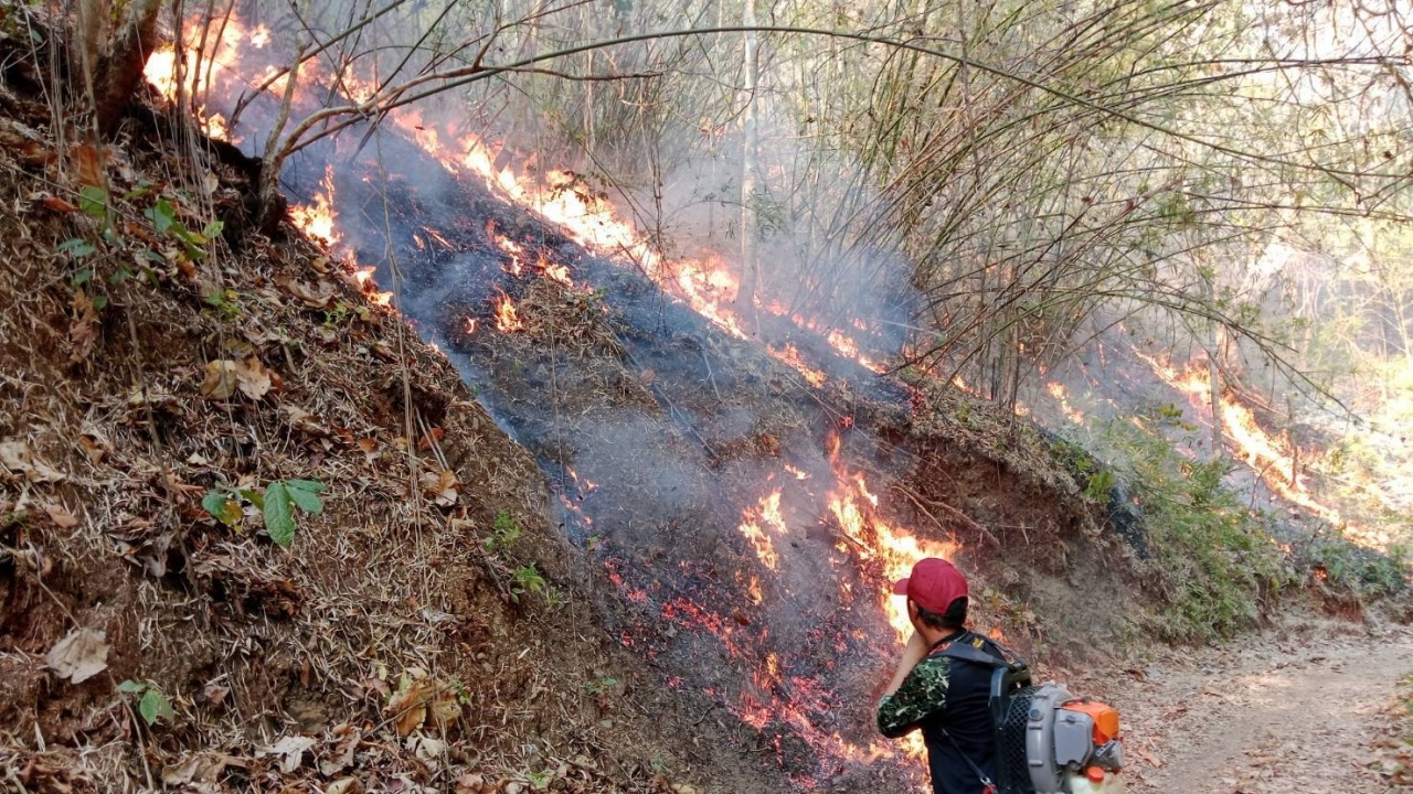
Mr. Worachak Panthong, District Chief of Mae Sariang, visited the area to monitor and command wildfire control after locals reported fires spreading near the Mae Sariang and Sop Moei district border, specifically at Nong Phak Nam Village, Mae Sariang Subdistrict, and Mae Katwan Subdistrict in Sop Moei. The fire is near Road 105 (Mae Sariang-Mae Sot). Officials used leaf blowers and foot patrols to create firebreaks along ridges to prevent flames from reaching villages and communities. The mountainous terrain is steep, and the fire reportedly spread from Sop Moei District over several days into Mae Sariang. Safety measures have been emphasized; in hazardous steep areas, firebreaks are created instead of direct firefighting to halt the fire's advance.

Recently, all districts in Mae Hong Son have been instructed to prepare water sources for aircraft to easily scoop water for firefighting. In Pai District, the Muang Paeng Subdistrict Administrative Organization was ordered to identify natural water sources (Pai River) where aircraft can safely access without flight obstructions. Excavators have dug into the Pai River to a depth of no less than five meters to facilitate water scooping by aircraft. Meanwhile, forest units continue patrolling day and night and use drones to detect illegal forest entry and arson, aiming to prevent the wildfire situation from worsening.