

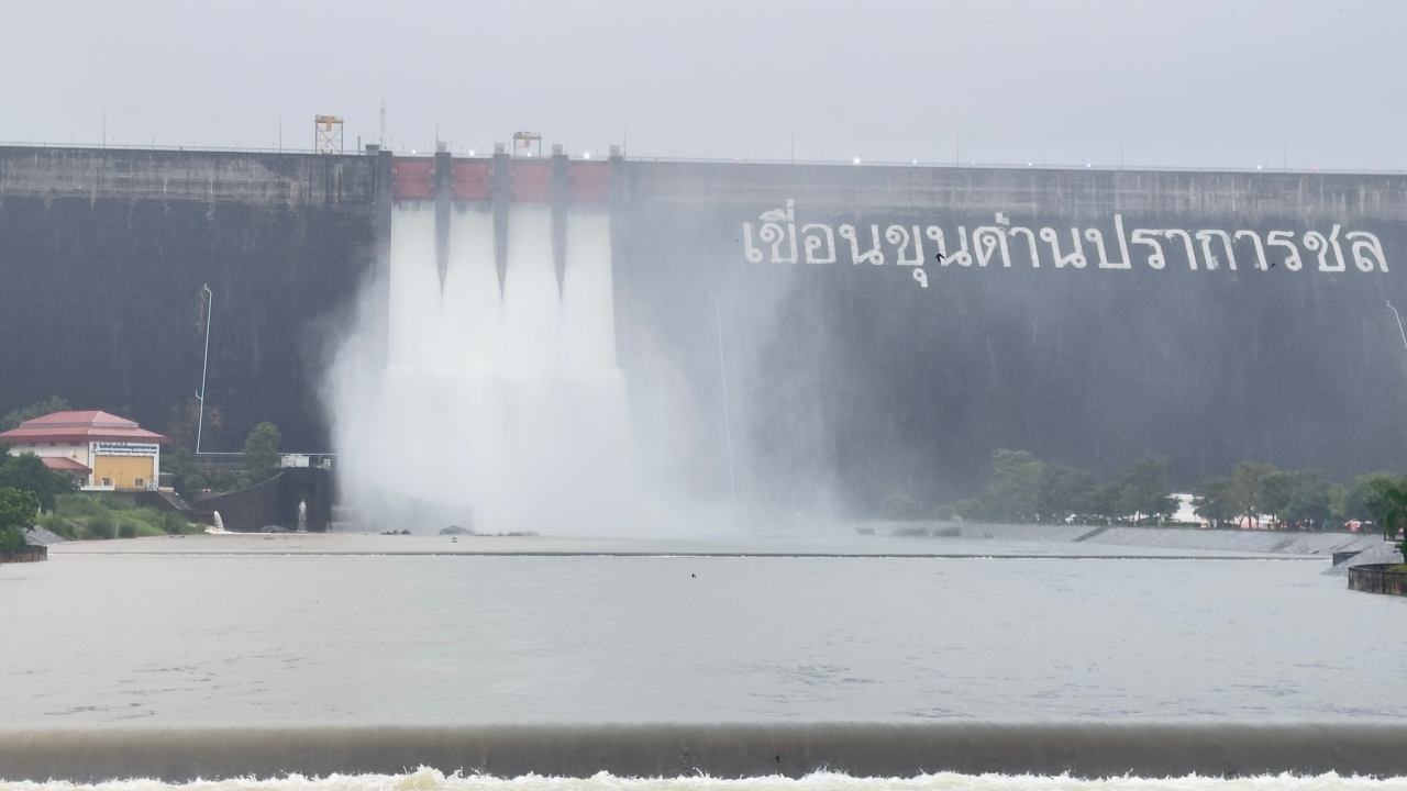
Flooding in Nakhon Nayok affects all four districts—Mueang, Ongkharak, Ban Na, and Pak Phli—with riverbanks overflowing and flooding homes in low-lying areas along the Nakhon Nayok River and its tributaries. Additionally, substantial water from Khao Yai National Park has flowed into the Khun Dan Prakan Chon Dam, making it necessary to increase water discharge.
On 27 September 2026 in Nakhon Nayok Province, reporters observed the Nakhon Nayok River's water level rising continuously with strong currents, causing flooding at Wat Pho Thinnayok in Nakhon Nayok Subdistrict, Mueang District. Surrounding areas of the temple experienced high floodwaters, with notably strong currents. The situation also impacted nearby community areas within Nakhon Nayok Municipality, especially roads around the temple submerged under water, preventing normal vehicle passage. Opposite the temple is the fresh market area, typically bustling with people and traffic, but it was noticeably quiet due to rising water and flooded roads, making travel in and out difficult.
From Wat Pho Thinnayok heading towards the traffic light junction at Tai Fa in central Nakhon Nayok, there was standing floodwater and strong currents. The surrounding area was flooded, and locals closely monitored the situation as water levels continued to rise. This affected the central city community, disrupting travel and commerce, with shops and markets facing a sudden downturn. Residents are advised to closely follow announcements from relevant authorities and exercise increased caution, especially in areas with strong currents and deep flooding.
Meanwhile, the Nakhon Nayok Provincial Command Center reported on the flood situation in the province as of 27 September 2026 at 12:00 noon.
1. Situation
Due to continuous rainfall in Nakhon Nayok Province since 25 September 2026, riverbanks have overflowed, flooding homes in low-lying areas along the Nakhon Nayok River and its tributaries. Additionally, large volumes of water from Khao Yai National Park have flowed into the Khun Dan Prakan Chon Dam, necessitating increased water discharge. Currently, the affected area includes 4 districts, 30 subdistricts, and 249 villages.
A total of 6,022 households are affected, with no reports of injuries or deaths.
1.1 Educational Institutions
(1) Thirty-five primary schools are affected, including 15 in Mueang District, 13 in Ongkharak District,
6 in Ban Na District, and 1 in Pak Phli District.
(2) Three private schools are affected, including Nayok Watthanakorn School, Wat Udom Thani School, and
Achariya Samphasa School.
1.2 Affected Routes Totaling 16
(1) National Highways
- Highway 3369, Wat Amphasirow - Khlong 16, km 7+700, water depth 15 cm, vehicles can pass.
- Highway 3369, Wat Amphasirow - Khlong 16, km 10+000, water depth 15 cm, vehicles can pass.
- Highway 3049, Thung Kabo Intersection, km 2+028, water depth 20 cm, vehicles can pass.
- Highway 3049, Pracha Kasem Intersection - Wang Yao Intersection, km 7+500 to 10+000, water depth 70 cm, small vehicles cannot pass.
- Highway 3239, Wat Srinawa Intersection, km 5+000, water depth 15 cm, vehicles can pass.
- Highway 3239, Wat Khiriwan - Wat Wang Yai Chim, km 9+400 to 12+300, water depth 80 cm,
small vehicles cannot pass.
- Highway 305, Tunnel Curve, km 45+900 to 46+200, water depth 10 cm, vehicles can pass.
- Highway 3222, Khao Perm - Ban Na, km 36+000 to 37+000, water depth 15 cm, vehicles can pass.
- Highway 33, Kaeng Khoi Intersection, km 114+000 to 115+000, water depth 15 cm, vehicles can pass.
- Highway 33, Thai Military Intersection, km 130+930, water depth 30 cm, small vehicles cannot pass.
- Highway 33, in front of BAAC, km 116+000 to 119+000, water depth 10 cm, vehicles can pass.
- Highway 3076, Nakhon Nayok - Bang Hoi, km 7+300 to 7+400, water depth 15 cm, vehicles can pass.
- Highway NY 2003, Highway 33 Intersection, km 120+550 - Ban Chaom, Ban Na District,
Nakhon Nayok Province, km 0+650 to +200, water depth 60 cm, passable but small vehicles cannot pass.
- Highway NY 4008, Highway 3239 Intersection, km 5+050 - Ban Nong Hua Ling, Pak Phli District,
Nakhon Nayok Province, km 0+000 to 0+200, water depth 30 cm, vehicles can pass.