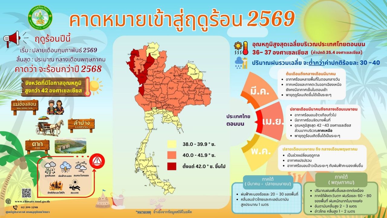
Prepare to say goodbye to winter. The Meteorological Department forecasts the 2026 summer season to begin late February and end mid-May, expecting it to be hotter than last year with maximum temperatures of 42-43 degrees Celsius.
On 31 January 2026, reports stated that the Meteorological Department anticipates the characteristics of Thailand's 2026 summer weather, noting that this year’s summer is expected to start later than usual (around late February), about two weeks behind the normal schedule, and will end around mid-May.
The weather will be hot and sultry intermittently, with thunderstorms in many areas at times, which will help reduce the heat. Some areas will experience very hot weather on certain days, mainly from April to May. The average maximum temperature in upper Thailand will be 36-37 degrees Celsius, which is higher than the normal average (35.4 degrees Celsius) and slightly above last year's peak average (35.8 degrees Celsius during summer 2025).
Average total rainfall will be 30-40% below normal. Each year during summer, severe storms often occur in several areas, bringing thunderstorms, strong gusty winds, and sometimes hail, which can cause loss of life, property damage, and agricultural losses. The rainfall may be insufficient for various needs in many areas, including consumption and agriculture, especially in drought-prone regions outside irrigation zones. Therefore, the public is advised to use water sparingly and efficiently and prepare to cope with these conditions.

General weather conditions
In upper Thailand, during early to mid-March, the weather will begin to warm, with hot weather in many areas during the day and thick fog in several places. However, northern and northeastern regions will remain cool in the mornings due to periodic high-pressure systems extending from China. These will weaken from late March to mid-April, during which low-pressure areas caused by heat will intermittently cover upper Thailand. Additionally, at times, southeast or southern winds will bring moisture from the Gulf of Thailand, resulting in hot and sultry weather almost everywhere, with some areas experiencing very hot conditions. Maximum temperatures will reach 42-43 degrees Celsius.
Mostly in the northern region, summer storms may occur intermittently, bringing thunderstorms, strong winds, and sometimes hail, which will help relieve the heat. From late April to mid-May, the transitional period between seasons, hot and sultry weather will persist intermittently with some very hot days. Weather will become more unstable with increased thunderstorms due to the southeast or southern winds over upper Thailand beginning to shift to the southwest monsoon.
In the southern region, from March to late April, east or southeast winds will cover the Gulf of Thailand and most of the south, causing thunderstorms in 20-30% of the area. Wave heights in both the Gulf of Thailand and the Andaman Sea will be about 1 meter. From then until around mid-May, rainfall will increase and continue, especially on the west coast of the south, where 60-80% of the area will experience rain, with heavy to very heavy showers in some places. Wave strength in the Andaman Sea will intensify, with waves reaching 2-3 meters at times, while the Gulf of Thailand will have waves 1-2 meters high due to the southwest monsoon covering the Andaman Sea and southern region.