Bangkok was established as the capital of Thailand by King Rama I in 1782 CE. Originally called Krung Rattanakosin, it was founded on the area known as "Bangkok" for strategic, geographic, and political reasons—especially its river surroundings, which provided natural defense. Historically, the selection of a capital was not based on popular consent but on state security and the centralization of power around the royal palace, following the ancient mandala system from the Ayutthaya era. The city grew concentrically outward from the palace, with inner rings housing nobility and outer rings divided by social status, forming a ring-like pattern around areas such as Khlong Ong Ang and Bang Lamphu.
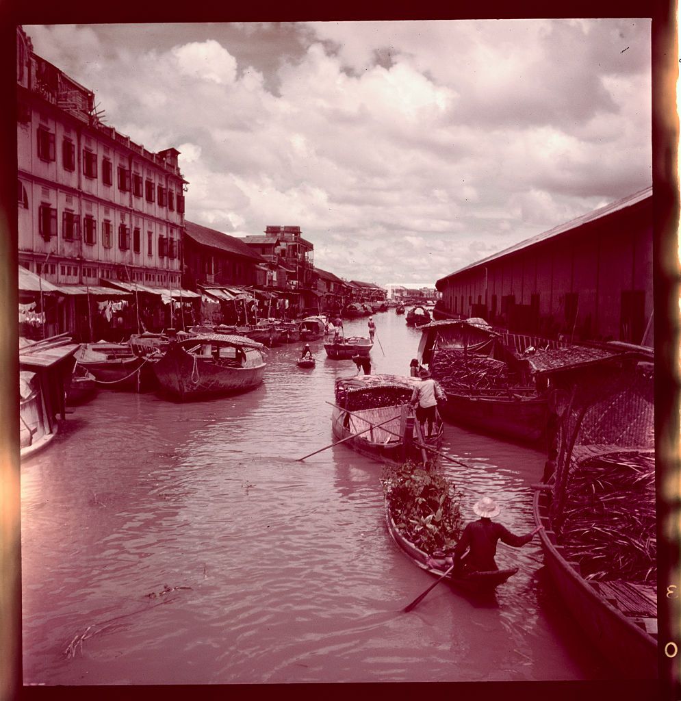
Bangkok’s terrain is a riverine lowland interlaced with numerous canals, so the primary mode of transportation was by raft or boat along these waterways rather than carts or walking. Westerners called Bangkok the "Venice of the East" because, like Venice, boats were the main means of travel. Transportation began to shift under King Rama IV with the construction of Charoen Krung Road, an 8-kilometer route starting from Sanam Chai near the Rot Damnoen circle, passing through economic hubs like Talat Noi and Bang Rak, and ending at the Chao Phraya River near Tha Trok Road.
 The city’s more structured urban planning began during King Rama V’s reign, who ordered the construction of buildings in the Dusit area and connected key points with the wide Ratchadamnoen Road in 1899 CE, inspired by his first European visit and by Paris’s Champs-Élysées. A tram system was also built to facilitate transportation along this road, which was divided into sections.
These three sections are: Ratchadamnoen Nok Road stretching from Si Ayutthaya Road
to Phan Fa Lilat Bridge; Ratchadamnoen Klang Road from Phan Fa Lilat Bridge to Phan Phiphop Lila Bridge; and Ratchadamnoen Nai Road from Phan Phiphop Lila Bridge to Sanam Chai Road.
The construction of Ratchadamnoen Road exemplified Infrastructure Led Development, emphasizing land-based transportation over the traditional water routes that had long been Bangkok’s main travel mode. The name "Ratchadamnoen" was intended to enhance prosperity for homes and gardens along the road by creating a prosperous commercial district quickly.
The Litchfield Plan: The Beginning of Concentrated Urban Growth
Bangkok expanded without systematic planning until 1960 CE, during the Cold War under Prime Minister Sarit Thanarat. At that time, the US supported Thailand as a strategic base to counter communism under the domino theory in Southeast Asia. The US established the United States Operations Mission (USOM) to aid military and infrastructure development.
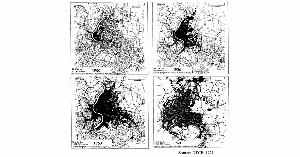 Growth of Bangkok from 1900 to 1968 is documented by the Department of Public Works and Town & Country Planning (1971) and further discussed by Roachanakanan, T. in "Bangkok and Asian Cities in Competition."
Initial research into Bangkok’s original city plan reveals that since 1960, a new comprehensive city plan was developed by the American firm Litchfield, Whiting, Bowne & Associates, which was primarily funded by USOM. The firm introduced an American-style urban model based on zoning by land use importance.
The American zoning system used then, known as Euclidean Zoning, organized land use by separating functions, such as placing residential areas on the outskirts and offices or commercial buildings in the city center, like in New York. Litchfield applied this model to Bangkok, shifting transportation focus from waterways to roads, building main roads to connect city areas and surrounding provinces, and improving drainage systems.
Euclidean Zoning has both advantages and disadvantages. Its benefits include preventing air and noise pollution in residential areas and controlling building types for uniformity. However, its single-use nature forces residents to travel longer distances, relying solely on cars, making walking to school or work difficult. Crucially, it causes traffic congestion at peak times, as commuters converge on bottleneck areas.
Ribbon Development and Cul-de-sacs: A Thai-Style Comprehensive Plan
Contrary to common belief, Litchfield’s involvement was limited to surveying and blueprint design over 2-3 years before returning to the US. The Thai government then took over actual city development, filling canals and constructing additional roads. Consequently, buildings of mixed types appeared along main roads—homes, shophouses, hospitals, and commercial areas—exemplifying Ribbon Development. For example, Chaeng Watthana Road features government offices, residences, hospitals, and shopping malls all on one street. This occurred because Bangkok lacked building regulations, resulting in over 30 years of mixed-use development until the first comprehensive city plan law in 1992, created by the Town Planning Department, with Bangkok Metropolitan Administration (BMA) adopting the second revision in 1999.
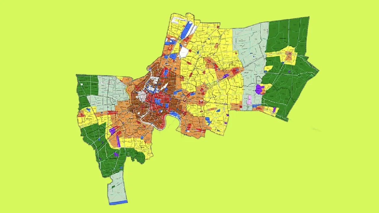
This comprehensive plan continued and built upon Euclidean Zoning’s land-use color-coded zoning, as seen in Bangkok’s zones:
Yellow/Orange/Brown areas: Residential zones ranging from low to high density.
Red areas: Commercial zones including business and shopping districts.
Purple areas: Industrial and warehousing zones.
Green / Green with white diagonal lines: Rural and agricultural zones / conservation areas such as eastern flood retention zones and coastal zones in Bang Khun Thian.
Additionally, Bangkok’s transportation plans included building secondary roads and new thoroughfares to improve car mobility. Previously, Bangkok resembled a superblock city, with main roads but lacking secondary roads, causing large neighborhood blocks with narrow alleys and canals—the historic main transport routes—to hinder internal travel. Although new roads were added later, the government delegated minor road allocation to private landowners. This created a fishbone street pattern of dead-end alleys owned by landowners, preventing through traffic. Residents still rely heavily on main and secondary roads, and population growth exacerbates traffic congestion.
Wan Chanthawilaswong, a data scientist, and Adisak Kanthamuangli, an urban geographer, co-authored an article on The Urbanis (under the Urban Design and Development Center, UddC) titled "The City of Dead-End Alleys," analyzing Bangkok’s alley patterns. They identified fishbone-style cul-de-sacs as the root problem in Bangkok’s city plan, constituting about 45 percent of the city's roads.
The article cites advantages of cul-de-sacs from Michael Southworth and Eran Ben-Joseph’s "Reconsidering the Cul-de-sac," noting these streets have slower traffic, greater safety for pedestrians and cyclists, easier security enforcement via guard posts, and potentially stronger privacy and community bonds. These cul-de-sacs reflect Bangkok’s historic lifestyle rather than intentional planning. The areas were once agricultural land with residences along canals for travel. As road use increased, landowners created minor roads mid-property to connect to main roads. Surveys show the highest cul-de-sac ratios are in Khlong Sam Wa and Rat Burana districts, with 54% of road length.
Sub-Center City Planning: A Better Solution (But Not for Everyone)
Today, urban planners view Euclidean Zoning as unsuitable for residents because it mandates car dependency, imposes strict prohibitions on mixed-use residential development (in some countries), and fosters social inequality by dividing neighborhoods. Although Bangkok does not apply this zoning rigidly, similar problems arise, including concentrated development in the city center.
If Euclidean Zoning is inadequate, what modern urban planning systems are effective?
Many major capitals like Singapore, Tokyo, and Paris employ Sub-Center or Polycentric planning, creating multiple urban centers. Singapore’s government established Regional Centres in areas like Tampines (east), Jurong (west), and Woodlands (north), each with business hubs, malls, government offices, schools, and hospitals, allowing residents to avoid traveling across the entire city.
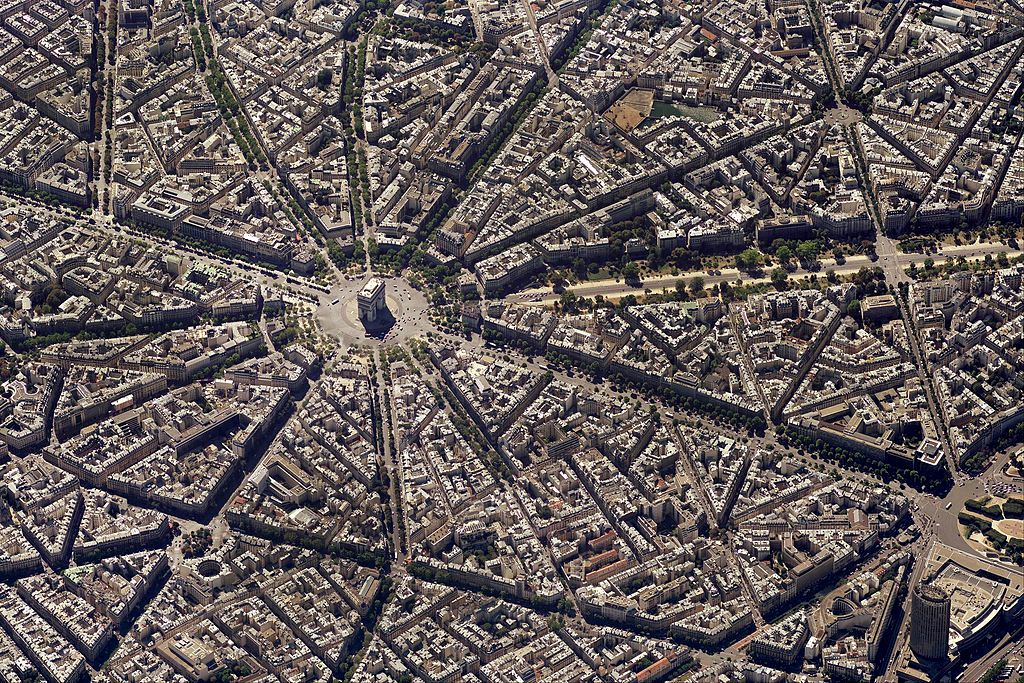
Paris notably implements the “15-Minute City” policy (La Ville du Quart d'Heure), dispersing amenities so residents can access essential services within 15 minutes by walking or cycling.
Paris’s clear initial urban design features a grid layout with small blocks and efficient car traffic flow. The polycentric zoning prevents congestion in any single area. For Bangkok, enforcing a grid and requiring all private developers to build through-roads is difficult. More important are building regulations and decentralization policies to avoid concentrated growth. This is complex for a capital city that developed chaotically. Consideration must include long-established resident land rights and other chronic issues. Therefore, the BMA must listen to all voices, as in the revised fourth draft of Bangkok’s master plan.
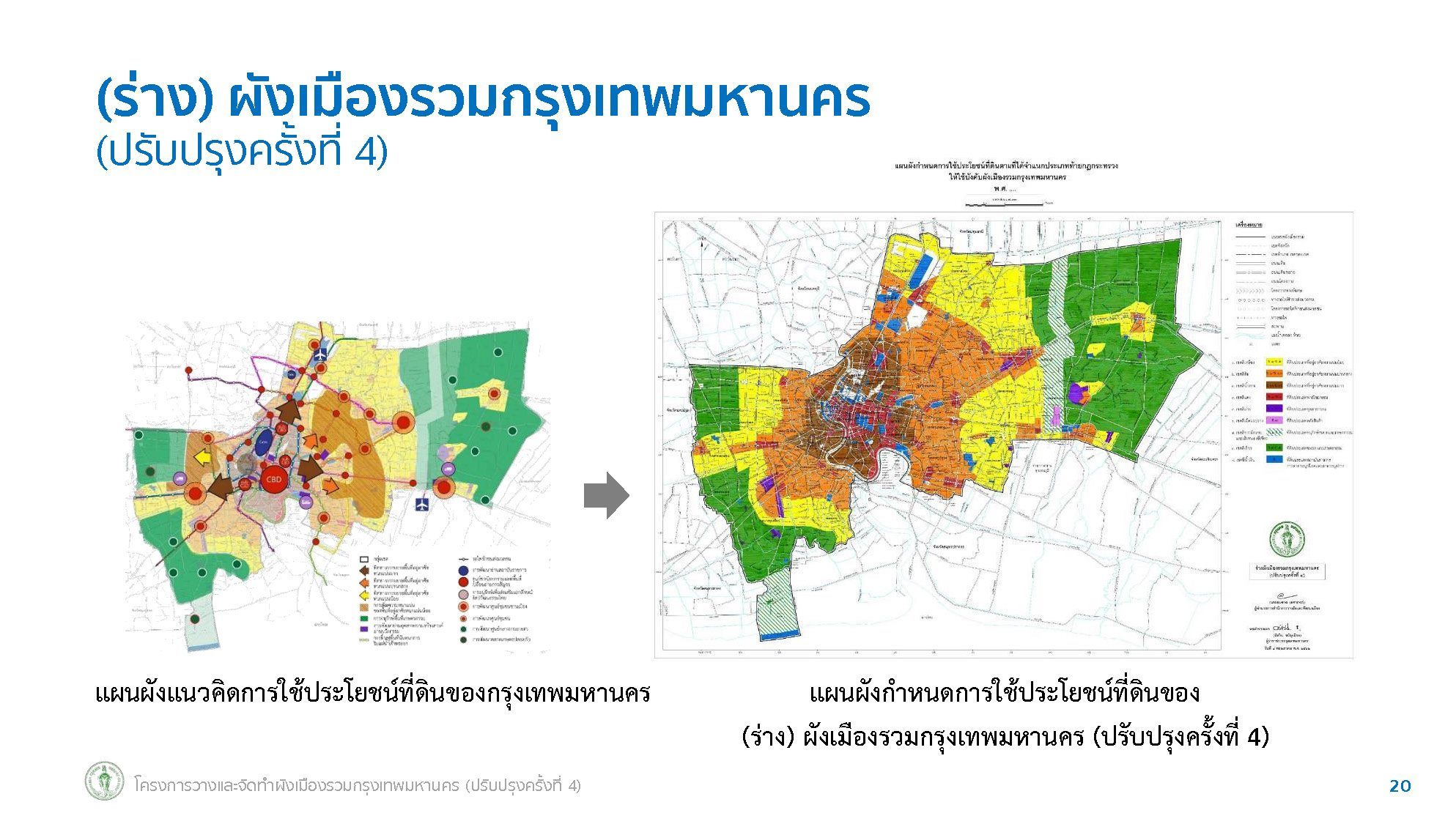
The current revision of Bangkok’s master plan updates the 2013 version, primarily adjusting zoning colors and land-use designations across nine main areas (More details are available hereSome areas have changed, notably residential zones shifting from medium to high density or from agricultural land to low-density residential. These changes support urban expansion from inner districts outward. Residents view these as favoring developers, since changing colors—e.g., yellow to orange or orange to brown—permits taller or larger buildings. The BMA claims this supports transit-oriented development along new rail lines.
Atthawit Suwanpakdee, former Bangkok MP from the Democrat Party and consumer representative, criticized the plan in the Consumer Council, saying it disregards residents and benefits developers by increasing private land values through road cuts. The Standard collected public objections citing issues from 148 proposed road projects and land expropriations, which threaten homes and heritage land, risking displacement and community disruption.
Additionally, the plan removes five flood retention areas, converting them into housing developments. Residents argue this worsens flood risks, as the BMA already lacks flood management measures.
The fourth revision highlights a lack of government cooperation with residents. Urban planners and environmentalists agree that Bangkok has no clear solutions for crises such as flooding (including major floods), PM 2.5 pollution, or green space expansion. Consequently, the BMA reduced the plan from 148 to 96 roads and extended the public consultation period.
Since urban lifestyles and city plans vary by country, careful adaptation is necessary, prioritizing residents. Bangkok cannot instantly decentralize or build new roads through neighborhoods without regard for inhabitants or rely solely on Euclidean zoning. The BMA must research, listen, and develop a capital city plan suited to local culture and residents’ lifestyles.
References: