

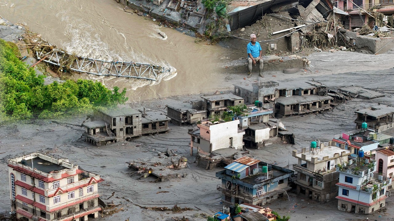
It is believed that a glacial lake burst and landslides created a temporary dam, leading to massive flooding in Nepal. Dr. Seri Supharath points out that Thailand could also experience temporary dams and that lessons on early warning technology are very important.
Regarding the case “Nepal Flood” A sudden major natural disaster occurred on the morning of 26 Aug 2026, when a massive volume of water and mud surged and flooded the border area between Tibet and Nepal along the Bhotekoshi and Lende Rivers. This area connects Rasuwa District (Nepal side) with Jilong District (Tibet side). As of 27 Aug, at least 162 deaths have been reported, with over 570 people still missing.
Nepal is considered one of the world's highest-risk disaster areas. Particularly amid global warming, large glaciers on mountain ranges are rapidly melting. The mountains lose stability and become prone to collapse. Meanwhile, the melting glaciers form large lakes at high elevations that risk overflowing into lower areas. Climate change also causes more intense heavy rainfall, which triggers major floods.

The exact cause of this recent flash flood and landslide is not yet clear. It may take weeks or months to definitively determine. However, three main causes have been proposed:
1. Most likely: Flooding caused by landslides of soil or rock.
On 26 Aug 2026 at 08:37 local time, the United States Geological Survey (USGS) reported seismic activity in the region, initially described as a magnitude 4.4 earthquake near the Nepal-China border north of Kathmandu. Simultaneously, reports indicated a snow and rock avalanche (likely resembling a landslide) fell from a cliff into the Lende River, a tributary of the Bhotekoshi River, which flows from China into Nepal through a deep valley.
USGS later clarified the seismic activity was not an earthquake but ground shaking caused by a landslide, equivalent to a magnitude 5.2 quake.
Daniel Schugar, a geologist at the University of Calgary, Canada, and part of the research team, said the hardest part is explaining exactly where the enormous volume of water mixed with mud came from. He suggested the landslide contained ice and rock, rushing rapidly down steep terrain and picking up sediment already saturated by monsoon rains.
“Rising temperatures may have accelerated landslides leading to this severe flood. Melted snow infiltrated cracks in glaciers and mountain rocks, weakening the mountain structure.”
Meanwhile, Thailand's Department of Mineral Resources' Geohazard Operation Center reported that snow and large boulders fell and blocked the Lhende River, creating a natural temporary dam that eventually collapsed, releasing a massive volume of sediment-laden water into the valley.

2. Possible cause: Glacial lake outburst.
Nepal is highly vulnerable to “glacial lake outburst floods” (GLOF) or flash floods caused by glacial lakes bursting. This occurs when glaciers melt into high-altitude lakes and water levels rise excessively, eroding icy or earthen banks until they collapse, sending water and rocks rushing down steep slopes.
Recent studies show the rate of glacial ice loss in the Hindu Kush-Himalaya region, including Nepal, has doubled since 2000, posing huge risks to nearly two million people living downstream.
The current event resembles floods in 2025 in the region caused by a glacial lake bursting in Tibet, releasing massive floodwaters. However, experts have yet to confirm whether a lake outburst contributed to this disaster.
Wolfgang Schwanghart, a geomorphology professor at Freie Universität Berlin, Germany, stated “It is unlikely.” Satellite images so far show no large glacial lakes along the flood path.

3. Very unlikely: Heavy rainfall.
This period is the region's wettest due to monsoon storms, some causing heavy rains last week. Seasonal rainfall combined with snowmelt in recent months raised river levels near banks. However, this is not believed to be the primary cause of the flash flood.
Thairath Online's special team discussed this with Assoc. Prof. Dr. Seri Supharath, Director of the Climate Change and Disaster Center at Rangsit University and Vice President of the National Disaster Warning Council Foundation, who sees two plausible theories for Nepal's flood: the first is a glacial lake outburst flood (GLOF), and the second is snow and rock avalanches forming a temporary dam that eventually collapsed, causing massive water and mud to flood downstream.
Asked whether this could happen in Thailand, Dr. Seri said it is possible but with different causes and severity due to different geography. Thailand does not have glacial lakes like Nepal, but heavy rainfall could wash soil, rocks, and trees to form “temporary dams.” Existing temporary dams might also break due to heavy rain washing away soil and rocks, unleashing huge water volumes suddenly and violently.
Dr. Seri noted such events have occurred in Thailand but were usually less severe and often unreported. A severe example was the Nam Kho–Nam Chun floods, when flash floods and landslides hit Khao Kho, Lom Sak, and Wichian Buri districts in Phetchabun Province during the early morning of 11 Aug 2001, causing 136 deaths, 109 injuries, 4 missing, with 188 houses fully destroyed and 441 partially damaged.
The chance of heavy rain causing temporary dams exists throughout Thailand but is higher in steep mountainous areas such as the North, West, and South regions.

Dr. Seri believes Thailand can learn the critical importance of disaster warning systems from Nepal's flood. Thailand currently lacks systems and technologies that detect and alert such events. Advanced countries use AI, radar imagery, or sensors to detect landslides and provide immediate warnings.
Currently, Thailand mainly forecasts based on “rainfall amounts.” For example, rainfall exceeding 90 mm is considered very heavy rain, triggering warnings on what actions to take and whether to send Cell Broadcast alerts.
“At present, it’s guesswork. For rainfall over 90 mm, caution is advised, but sending Cell Broadcast alerts requires certainty to avoid unnecessary panic.”

Each area has different geological conditions, and it remains unclear how much rain triggers landslides. Dr. Seri says studies can be done in each risk area, but there are many such locations, and severe events are rare, so authorities often neglect them. There is also a shortage of personnel. Universities could assist if local governments provide funding.
“Local authorities may undervalue the risk because severe events happen infrequently. Some residents have lived 50 years without such incidents and assume heavy rains are normal. But rainfall intensity has increased compared to the past, mainly due to global warming.”
Dr. Seri also recommends Thailand adopt new technologies and upskill disaster officials to keep pace with future threats. This year, a massive flood like in 2011 is unlikely, but localized floods may occur in areas such as the West (Mae Hong Son, Tak, Kanchanaburi), the North and Upper Northeast near the Mekong River, and the South after November.